Overview
Within each large fire selected for study, we sampled across the full range of burn severity classes (low, moderate, and high) within each vegetation type present. Field sites were randomly selected within large patches of a given burn severity, known a priori in part with the aid of Burned Area Reflectance Classifications (BARC) maps. Sampling areas were generally located within 200 meters of a road to facilitate access. At each site, plots were situated along transects at a great range of lag distances. Variable lag separation distances optimize the distribution of lag distances separating plots, and subplots within plots. Tree, vegetation, forest floor litter, and microtopographical characteristics were measured in fixed plots. Duff and both pre- and post-burn litter depths were measured, and fractional cover of mineral soil, ash, photosynthetic and non-photosynthetic material were determined within subplots. We resampled the same points in each fire one year after burning.
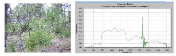
Endmember Spectra
Reflectance spectra of important ground cover constituents were obtained using a handheld field spectroradiometer (Full Range Field Pro, Analytical Spectral Devices) with high spectral resolution in the 350-2500 nm range, which will be useful ground validation for multispectral or hyperspectral imagery with potential for remote mapping of burn severity. Endmember spectral signatures will be added to a permanent spectral library to be used in spectral mixture analysis to "unmix" each image pixel into its fractional components: char (low, moderate and deep), photosynthetic and nonphotosynthetic vegetation, uncharred soil (there may be several types) and rock.
The spectral library will be supplied to the Remote Sensing Applications Center and the USGS Earth Resources Observation Systems Data Center and designed for continual updates, allowing future fires in the same ecotype to be quickly mapped using spectral mixture analysis, perhaps eventually for the purpose of rapid response should we find spectral mixture analysis to be the most accurate approach to burn severity mapping. Our field data will provide spatial and spectral validation for most remote sensing systems with potential for mapping burn severity, ranging from high (e.g. IKONOS) to coarse spatial (e.g. MODIS) resolution satellite imagery, and hyperspectral imagery.
| Fire | Multispectral Satellite | Hyperspectral | Fire Mapper |
|---|---|---|---|
| Black Mountain 2, MT | X | X | X |
| Cooney Ridge, MT | X | X | X |
| Robert, MT | X | X | |
| Wedge Canyon, MT | X | X | |
| Simi, CA | X | X | |
| Old, CA | X | X | X |
| Porcupine, AK | X | X | |
| Chicken, AK | X | X | |
| Wall Street, AK | X | X |
How We Operated
We had two detailed operating plans, one each for pre/during-fire operations and post-fire operations. We reviewed our plans with each Geographic Area Coordination Center and Incident Management Team for the particular incident(s) we wished to sample. Our during-fire chief of operations, Ed Matthews, and post-fire chief of operations, Andy Hudak communicated routinely with the Incident Management Team in person and via radio.
The during-fire operations involved a 6-8 person research crew led by Sharon Hood and Helen Smith. In addition, on selected wildfire incidents, an aircraft managed and operated by Forest Service Research conducted airborne infrared remote sensing overflights from a nominal altitude of 1525-2450 meters above ground level, all of which were coordinated through the appropriate Air Operations authority.
The post-fire operations involved 6 to 8 other people led by Leigh Lentile and Sarah Lewis. The post-fire research team sampled where the fires had been extinguished, well removed from any fire fronts, to preclude any potential interference with the Incident Management Team.
All Rapid Response personnel practiced the LCES system (Lookouts - Communications - Escape Routes - Safety Zones) at all times, had personal protective equipment to current standards, had completed annual standards for survival training, and had successfully passed the appropriate work capacity test. All fire research personnel working on active wildfires also held current minimum red card qualifications at the FFT2 level or higher, including current physical fitness at the arduous level.